Part of HIST 301: Indigenous Histories at Carleton (Fall 2024). Prof. Meredith McCoy, Carleton College.
By Lucy Watson ’26 and Annika Gursky ’26
In between Boliou and Olin Hall stand two bur oak trees. These trees, with their rounded crowns, furrowed bark, and glossy leaves, have stood rooted in place for 200 years, predating the College by nearly 50 years. The bur oaks are windows into the ecosystems on campus before settlers dispossessed Wahpekute and Mdewakaton Dakota of their homelands. From cleared old-growth forests to prairie flattened into farmland, much of the land that has been stewarded by Dakota peoples since time immemorial has been radically altered by settler colonialism. Have you ever wondered how Carleton’s landbase has changed since settler intervention?
Visualizing this change is challenging because knowledge of the land pre-contact is seldom preserved in the historic record. So, to answer this question, we turned to the earliest sources available that visually describe the land – settler plat maps.
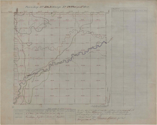
In the early and mid-1800s, as the U.S. government dispossessed Native lands, Congress issued a project through the General Land Office to create maps of the land. These maps methodically measured land into sellable portions and took account of the resources available for settler use, such as timber and feasible farmland. Rather than Dakota conceptions of land as a relative, within which territories are shared and stewarded, the plat maps convey a settler understanding of land as individual property with resources to be extracted.
The plat map that records Carleton’s landbase was created in July of 1852. You may recognize familiar landscape features, like the winding Cannon river that crosses the map, or Spring Creek which runs right through current-day Carleton campus.
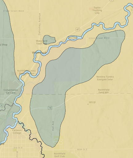
In order to envision the ecology of the land before settler dispossession, we interpreted plat map resources (e.g. timber) as indications of habitat type (e.g. woodland). Through GIS mapping technologies and with the support of Cherokee scholar Joshua Friedlein and Carleton Assistant Director for Digital Humanities Austin Mason, we overlaid the plat map with a current GPS map to highlight habitat location in relation to today’s landscape. The green shapes indicate Big Woods forest, the winding blue sections show waterways, and the yellow regions are indicative of prairie ecosystems. This map is modeled after a map Joshua created as part of the Indigenous Chicago project with the Newberry Library, an extensive exhibition affirming that Chicago has always been a Native place.
When looking at our map, you may notice several pointed differences in the land today as the College has modified the landscape to fit its desires. For example, Carleton cleared Big Woods forest to establish the Carleton Farm (what is now the Lower Arboretum) and dammed Spring Creek to create the Lyman Lakes. Another change Cowling Arboretum Director Nancy Braker ‘81 pointed out was the re-routing of Spring Creek around Bell Field for more convenient access to viewing sporting events. These changes in the landscape show the tangible appropriation of Dakota homelands by Carleton College.
Maps are significant not only in their representations of geography and, in our case, landscape change, but in their role as social and cultural objects which create and define worlds. In using settler plat maps to reveal physical land changes, it is important to acknowledge how the plat maps themselves intentionally erase Dakota place names, histories, and records of existence. Maps carry powerful narratives of space, and engaging with historical maps of this area help us to understand the erasure and destruction of settler colonialism to Dakota land. Although we engage with these settler resources, our map aims to confront Carleton’s history of settler colonialism and land dispossession, and strives to engage in honest storytelling.
As this map is further developed, it will become a part of Carleton’s Indigenous Engagement in Place initiative, a three-year initiative funded by the Mellon Foundation. The Indigenous Engagement in Place initiative works to “expand curricular and scholarly collaborations with Indigenous partners to enliven learning, teaching, and public scholarship in the humanities and across the liberal arts.” One goal of the project is to create a module for new students and faculty that tells honest stories of Carleton’s history in a Dakota place. The map will be one component of the module as a way to create a stronger sense of, and responsibility to, place.
Works Cited
Mason, Austin, Annika Gursky, and Lucy Watson. “Indigenous Engagement in Place Map” [Web Map]. Scale Not Given. “Indigenous Engagement in Place Master Map.” November 7, 2024. ArcGIS Online. (November 7, 2024).
General Land Office and U.S Surveyor General. Minnesota: Township 112, Range 19. 1854. Plat map MHS1395, no scale given. GLO Historic Plat Map Retrieval System, Minnesota Geospatial Information Office. https://www.mngeo.state.mn.us/glo/glo.php?township=112&range=19.